Summer Wanderweg: Favorite Hiking Trails of 2022
Friends. I am starting this blog post on MAY 23rd! MAY! 23rd!
I think (hope) the Swiss weather gods really felt bad about the 2021 summer they dealt us, so they are going to make it up to us this year. We’ve already had a few above-30 degree days, which is…unseasonable, to say the least. But it means we can start hiking season, so grab your boots and poles and come along for the ride.
Like all my hiking posts, I’ll be adding to this as I go throughout the season. Most hikes we do in the summer are rated moderate to challenging, but generally none are technically difficult. For those new to Swiss hiking, start here. And for more trails, check out my 2021 hiking, 2020 hiking, 2019 hiking, 2018 hiking lists.
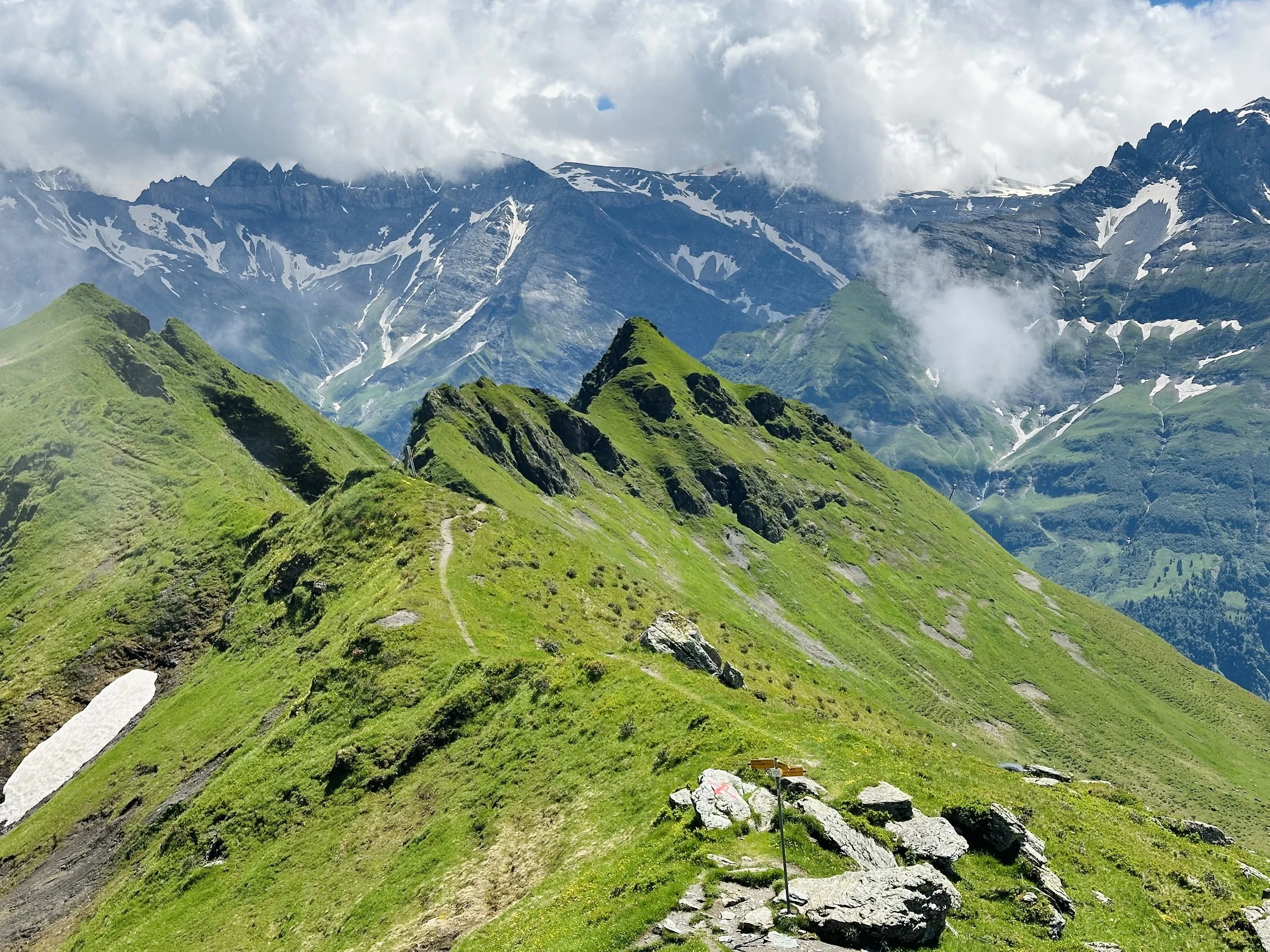
Amden to Speer: St. Gallen
Leglerhütte: Glarus
Val Frisal: Grisons
Alp Tschingla: St. Gallen
Höhenweg Maderanertal: Uri
Stöckalp to Abgschütz: Obwalden
St. Jakob to Rugghubelhutte: Uri and Obwalden (coming soon)
Balmeten: Uri (coming soon)
First-Wart Loop: Jungfrau Region
Weisstannen to Pizol: St. Gallen
Alp Mora: Graübunden (coming soon)
Gastlosen loop: Fribourg (coming soon)
Amden to Speer: St. Gallen, Eastern Switzerland

There’s really nothing like the first big hike of the season, where it’s probably more of a struggle than it should be, but it just feels so good to be out in the mountains again that sore muscles be damned, I can’t wait to do this all summer.
This hike is up to Speer, which at 1951 meters doesn’t seem all that intimidating - until you see it. I started at Amden, and somewhat foolishly skipped the chairlift, which added 350 meters (and unnecessary sweat) to my day. The first section winds around the Mattstock (another climb for another day!), and doesn’t start climbing for a while - but once it does, it is steep and feels relentless. Eventually, Speer comes into view, and it looks farther and higher than possible for a day hike. There are a couple snowfields to get through, but all are passable with clear tracks. Once at Oberchäseren, I was exhausted, and really debated whether I wanted to go further. But at that point, you can start to see the little figures of the other hikers who had made it to the top - and I wanted to be one of them. So I pushed on, and let me tell you, it felt GOOD climbing those last steps. The descent is a knee-busting, but beautiful, 2.5 hours, weaving through the forests until the trail suddenly opens with views down to the always stunning Walensee. All in all, an excellent season opener.
Start/End: Amden (to shorten, take the chairlift from Amden to Niederschlagwald)
Basic Route: Amden - Niederschlagwald - Hinter Höhi - Oberchäseren - Speer - Oberchäseren - Unterchäseren - Durschlegi - Amden
Length and Rating: Challenging. 19km, 1100 meters ascent/descent, 5-7 hours.
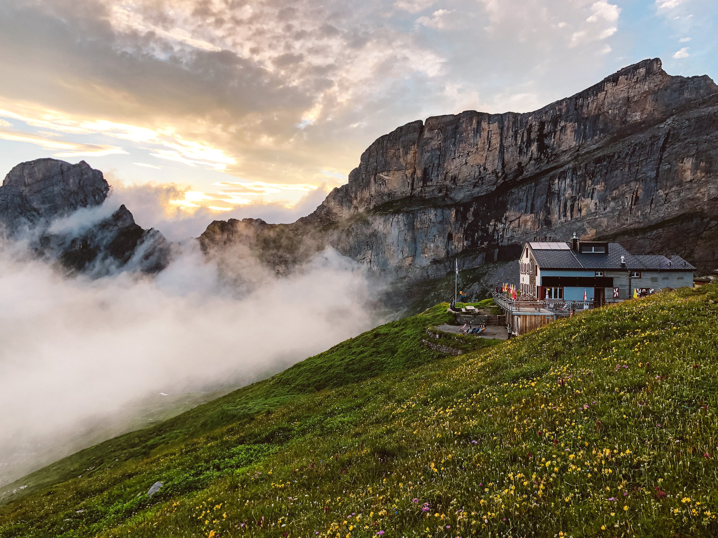
Leglerhütte: Glarus

This hike exceeded expectations in all the best ways: with bigger mountains, brighter colors and lots of little surprises. Like the ***stunning*** panoramic view from Leglerhutte, which is completely hidden until the last few steps up to the hut, and thus completely blew my mind when we arrived at the top. Or the little turquoise Ängiseen, with water so perfectly clear and so ice cold we could only stay in for a few minutes. Or the marmots and the pair of chamois running around the mountain plateau, which I always feel so lucky to see.
This hike really shows off all of the Glarnerland’s best sides. I loved how the path up to the hut had nearly a completely different landscape than the (albeit never-ending) hike back down on the other side. Some parts of the trail are steep, but it’s all worth the effort in the end. Make sure you budget some extra time to hang out at the hut on top - trust me, you won’t want to leave.
Start/End: Kies (to shorten the ascent, take the Kies-Mettmenalp gondola)
Basic Route: Kies - Mettmenalp - Matzlefurggeln - Leglerhutte - Angisee - Ratzmatt - Kies
Length and Rating: Challenging. 16km, 1370 meters ascent/descent, 5-7 hours.
Val Frisal: Grisons, Surselva Rhine Valley

** Description coming soon **
Start/End: Brigels (Cuort)
Basic Route: Brigels (Cuort) - Alp da Stiarls - Chischarolas - Alp Nova - Frisal - Chischarolas - Brigels (Cuort)
Length and Rating: Moderate. 12km, 840 meters ascent/descent, 3-4 hours.
Alp Tschingla: St. Gallen, Eastern Switzerland

Full disclosure: I did this hike in late November of 2021. But I never wrote about it, so it’s going on my summer 2022 list, which isn’t even really a lie because this trail is so nice, I’ll probably repeat it this summer anyhow. The path is one long loop above Walensee, with some of the best views in Eastern Switzerland. Most of the steep climbing is all at the beginning, and then the rest of the trail is a beautiful meandering path right below the Churfirsten mountains (and if you end up doing this hike in the fall, you’re above the fog line, too!).
I read on other blogs that the hike up is potentially dangerous, with steep-drop offs in some sections. However, nothing about the trail made me nervous (which, given my fear of heights, is saying something!). So while I felt this needed to be mentioned, I personally didn’t have any problems.
Start/End: Rehabilitationszentrum Walenstadtberg
Basic Route: Walenstadtberg- Tschingla - Pallis - Hochrugg - Walenstadtberg
Length and Rating: Moderate. 12km, 900 meters ascent/descent, 4-5 hours.
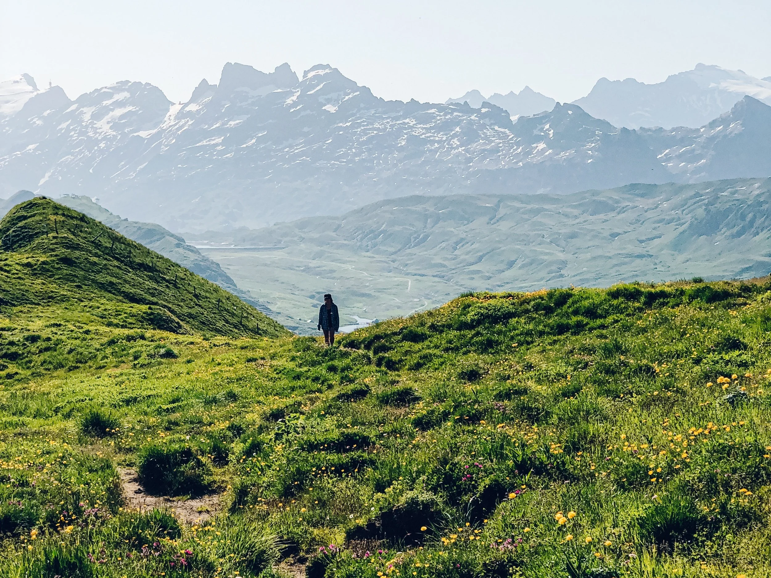
Höhenweg Maderanertal: Uri

This is a “pictures can’t do it justice” hike if there ever was one. Canton Uri has a verifiable goldmine of incredible hikes, and the hike up through the Maderanertal to the Windgällenhütte and down to Golzerensee is no exception. We started this hike in Bristen, and opted to skip the gondola and hike up instead (which, as you all probably know by now, is always my preference!). There was a near constant 360-degree panorama of waterfalls and mountains as we walked up through quiet valleys filled with glacially-cold streams and wildflowers and butterflies, and if that doesn’t sound like hiking perfection I don’t know what does. The Windgallen Hut is the highest point on the trail, and makes for an excellent rest stop. And did I mention that it ends at an alpine lake? Where you can cool off your sweaty body and laze around on the swimming platform and stare up at the mountains all around you without a care in the world? Oh yeah. It’s real good.
P.S. The gondola runs until 8pm in the summer!
Start: Bristen (Talstation)
End: Golzern (Bergstation)
Basic Route: Bristen - Tritt- Windgallenhutte - Golzerensee - Golzern
Length and Rating: Challenging. 18km, 1200m, 5-6 hours.
Stöckalp to Abgschütz: Obwalden

Ok, we worked harder than necessary to get to this viewpoint. There is a perfectly capable gondola that will whisk you up from Stöckalp to Melchsee-Frutt in 10 minutes, and save you 900 meters of climbing (which is probably why we were the ONLY people on the trail). From Melchsee-Frutt, it’s only about 4 kilometers and 300 meters until the Abgschütz plateau and a truly, truly magnificent view. This was part of an overnight trip for us, but it can easily be done as a day hike.
Start: Stöckalp
End: Abgschütz
Basic Route: Stöckalp - Bettenalp - Melchsee - Abgschütz
Length and Rating: Moderate
St. Jakob to Rugghubelhütte: Uri and Obwalden
Start: Isenthal, Seilbahn St. Jakob
End: Rugghubelhutte (or Ristis for a day-hike)
Basic Route: St. Jakob - Gossalp - Bannalper Schonegg - Rotgratli - Rugghubel Hut - [as a day hike: continue to Ristis for connection to Engelberg]
Length and Rating: 16km, 1700 meters, 6 hours. Challenging
First-Wart Loop: Jungfrau Region

A more off-the-beaten track hike than the classic (and very popular) Schynige Platte to First hike is this one: a round-trip trail beginning and ending at the First Bergstation, with a big steep sweaty climb, fun rocky landscapes, two hidden alpine lakes, one not-so-hidden alpine lake (the gorgeous Bachalpsee), and all the mountain views that made the Jungfrau region famous. And - you’ll get a majority of the trail to yourself, which, given how busy the area around Grindelwald can get, makes it even more special.
Don’t underestimate the length! My legs were jelly by the end of it. There are a couple ways to shorten the hike if you’d like. You start at Grosse Scheidegg instead of First, or you could do straight to Bachalpsee and skip the Tierwang portion. Just remember that in the summer, the last gondola from First to Grindelwald is at 6pm.
Start/End: First Bergstation
Basic Route: First - Oberlager - Wart - Tierwang - Bachalpsee - First
Length and Rating: 20 km, 1200 m ascent, 6-7 hours. Challenging
Weisstannen to Pizolhütte: St. Gallen

I’ve wanted to do this one ever since we hiked to the Batöni waterfalls last summer, and saw that there was a route that connected to Pizol. This one requires stamina: it has a significant amount of elevation gain, and is a steady climb from the village up to the highest point above Wildsee. The two steepest climbs are at the very beginning, and near the end. The views just keep getting more and more stunning - first the lower valley, then the three waterfalls, then the view of the waterfalls from above, then the higher valley, then all the mountains, and THEN, for a finale - the stunning Wildsee. There were only a couple other hikers with us for the majority of the trail…but prepared for a shock once you reach the lakes. The Wildsee is part of the **insanely** popular Pizol 5-Lake hike, and the crowds are real. That’s another great thing about this hike: you get most of the trail to yourself.
Don’t forget to check the chairlift/gondola times from Pizolhutte!
Start: Weisstannen, Oberdorf
End: Pizolhütte
Basic Route: Weisstannen - Batöni - Lavtinasattel - Wildsee - Pizolhütte
Length and Rating: 12km, 1700 meters ascent, 5-7 hours. Challenging.
Alp Mora: Graübunden
Start: Bargis
End: Trin
Basic Route: Bargis - Alp Mora - Gleschermuhlen - Trin
Length and Rating: 20 km, 900m up/1600m down, 5-7 hours. Challenging
Gastlosen Loop: Fribourg

Start/end: Jaun
Length and Rating: 11 km, 750 up/ down, 4 hours. Moderate.
![Raunaq's Hikes - Part 1: Kesch Trek [Guest Post]](https://images.squarespace-cdn.com/content/v1/5c33451b710699b10e8e4576/1664451604215-M4NKRUC7BKIGB3ZCARC5/20220911_160546.jpg)