Summer Wanderweg: Favorite Hiking Trails of 2021
After a long cold winter and a longer rainier spring (seriously, it rained nearly the entire month of May), summer has finally arrived in Switzerland. And that means one thing: hiking season! It’s our fourth summer here, but with a never-ending “to hike” list, I have a feeling it might be our best one yet*.
Like all my hiking posts, I’ll be adding to this as I go throughout the season. For those new to Swiss hiking, start here. And for more trails, check out my 2020 hiking, 2019 hiking, 2018 hiking lists.
Grindelwald to Bäregg: Jungfrau Region
Heinzenberg Gratweg: Graubünden
Saxer Lücke: Appenzell
Ringelspitz Hut Loop: Graubünden
Seewlisee: Central Switzerland
5 Lakes Hike (GH): Andermatt
Tremorgio to Dalpe: Ticino
*Note from Future Alex: Unfortunately, summer 2021 was the rainiest summer we’ve ever experienced. Storms were an almost daily occurance. It rained most of July. It rained so much that Lake Zurich flooded. But we made the best of it!
Batöni Waterfalls: St. Gallen, Eastern Switzerland
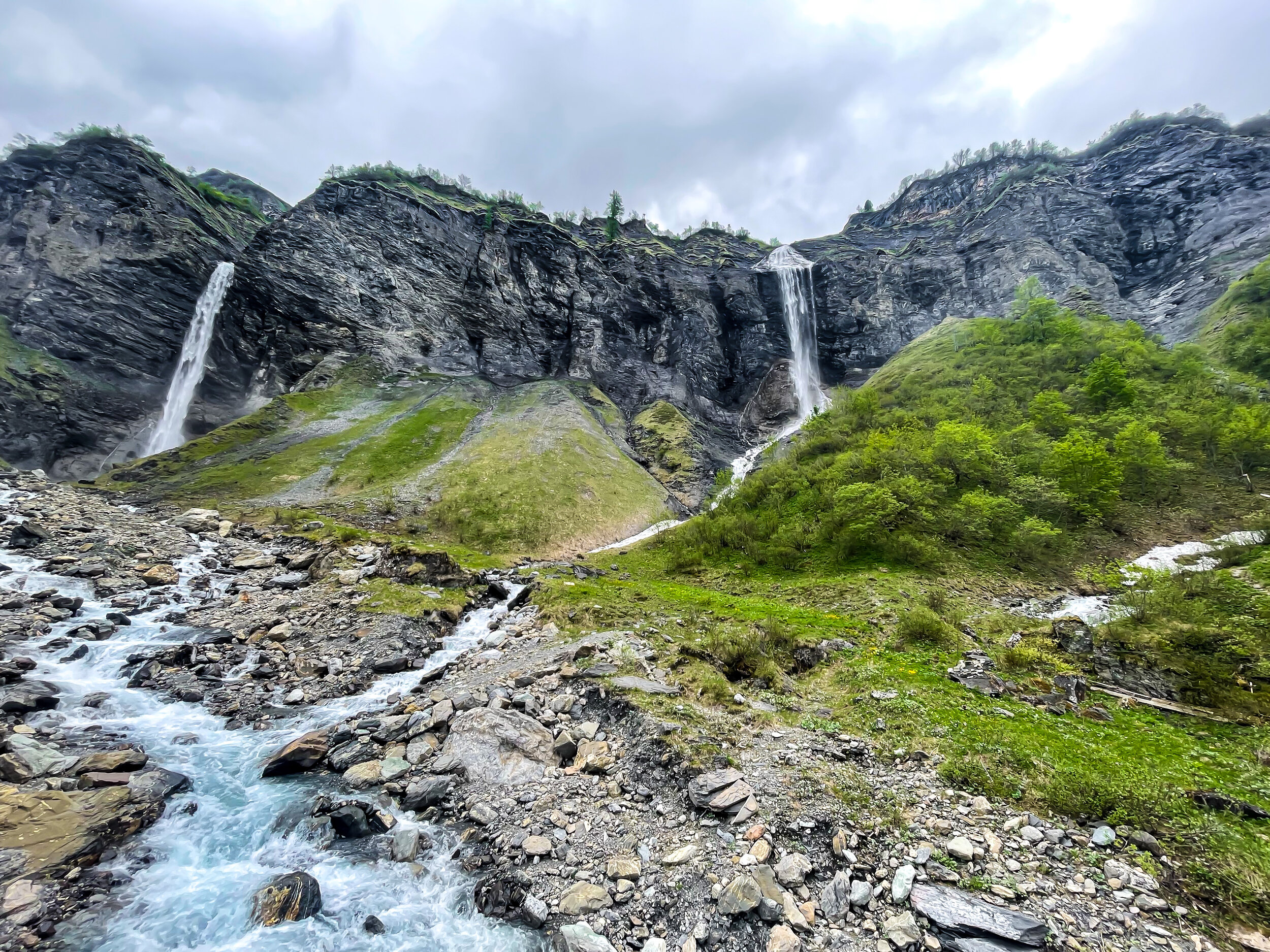
I somehow spent the last three years hiking in Switzerland without ever hearing about the Batöni waterfalls. But when I saw a picture of them on a Friday night, I immediately said to Raunaq, “That is where we need to be.” So we went! And I barely have the words, it was so beautiful. It’s an out-and-back trail, which is great because the views of the valley from both directions are spectacular. The hallmark of the trail are the trio of waterfalls, which are stunning and insanely dramatic from every angle. And bring binoculars if you have them! This area has a federal hunting ban, so there is a really good chance of seeing chamois or ibex. We saw a large family of chamois scampering around high up on the rocks.I loved every bit of this hike, and only wished we could have continued further up the mountains (alas, it’s too soon in the season). We will absolutely be back.
More photos of Wasserfall-Arena Batöni
Start/End: Weisstannen Oberdorf
Length and Rating: Moderate. The first 3 kilometers are pretty steep, but the path evens out in the valley after that. 8km, 560 meters ascent/descent, 3-4 hours
Grindelwald to Bäregg: Jungfrau Region

A new favorite hike in this region! From Grindelwald valley, the climbing starts right away - and doesn’t end until you reach the Berghaus Bäregg at 1774 meters. The initial forest section is steep, but once you emerge the views really make all the sweat worth it. The trail winds up above the Gletscherschlucht (canyon), and the setting is really spectacular: waterfalls spouting from the mountainside, snowy peaks, and glaciers. It’s incredibly epic. There are no areas of true exposure, but there are some part of the Pfingstegg-Baregg stretch that made me a bit nervous. I mean, you’d have to try really hard (or stumble really bad) to actually fall off the cliff - but let’s just say you want to watch your step.
You can shorten this hike by taking the Pfingsteggbahn, but that would make it a pretty short hike. Grindelwald is pretty far for a day trip, so when we make the trek to this area, we like to make sure we are getting in a substantial hike!
More photos of Grindelwald to Bäregg Hut
Start/End: Grindelwald
Basic Route: Grindelwald - Pfingstegg - Baregg - Pfingstegg - Grindelwald
Length and Rating: Challenging. 12 km, 800 meters ascent/descent, 3-4 hours.
Heinzenberg Gratweg: Graubünden

I’m a bit floored that this hike isn’t more popular. I think we saw all of 10 people on this trail, and it is super, super, SUPER schön. There are wildflowers of every color, views into the depths of the rugged Safiental valley and the Ruinaulta, alpine pastures, tiny ‘more pond than lake’ lakes, and it is completely snow-free at the moment (woot!). It’s slightly more difficult/narrow than Stoos Ridge, but it’s still definitely a “baby” ridge. Raunaq called it a “narrow panoramic path” instead of a ridge - to which I countered, “Isn’t every ridge technically a “narrow panoramic path??” But I digress. No matter what you call it, what we all can agree on is that it is panoramic: mountain views of all the Graubünden Alps in every single direction. Super schön. The descent is a bit of a slog (~1000 m down in 4 km, oof), but not as tough on the knees as you might expect. There’s no getting around it, either. But well, sometimes that’s the price you need to pay for a nearly empty ridgeline. A price I’m very happy to pay!
More photos of Heinzenberg Gratweg
Start: Obertschappina
End: Präz
Basic Route: Obertschappina - Glas Pass - Glaser Grat - Tguma - Präzer Höhi - Präz
Length and Rating: Moderate. 18km, 1050 m / 1400 m, 5-6 hours
Saxer Lücke: Appenzell

We set out on this hike to see the famous Saxer Lücke spiky peaks...but the whole landscape is such a dream. The birds eye views over Sämtisersee and Fälensee, the tiny huts way down in the valley, the fog rolling in and out through the sharp ridges. Even though the clouds obscured some of the views, and most of Saxer Lücke’s peaks, it was still an amazing day of hiking. This hike is broken up into a few different stages, with a couple good places to stop for lunch or refreshments (like Staubern or Bollenwees at Fälensee). Have lunch at Bollenwees for the best rösti of your life. They deep-fry it and it is to die for. Worth noting that the trail is rocky and narrow in some parts, and it was a bit slippery and muddy when we hiked (after a week of rain). If you are not super sure-footed or nervous of heights, wait for a sunny day after a few sunny days, so everything is nice and dry.
The descent from Bollenwees to Brülisau is one of the worst. Pretty, but knee-busting. I’d recommend saving some energy and climbing back to Staubern to take the cable car from there. OR! For a beastly but EPIC day, try this route: Wasseraun - Seealpsee - Meglisalp - Widderalpsattel - Bollenwees - Saxer Lücke - Staubern (with cable car connection). Basically, this will combine the highlights from the 3 Lakes Trail with the Saxer Lücke trail. It will be a big hiking day with lots of ascent, but a pretty stunning way to experience the best of the Alpstein.
Start: Hoher Kasten
End: Brülisau
Basic Route: Hoher Kasten - Staubern - Saxer Lücke - Bollenwees - Brülisau
Length and Rating: Moderate. 18km, 5-6 hours
Ringelspitz Hut Loop: Graubünden

Even though we only could complete half this hike, I’m still giving it a winning review. The wild and remote Lavoitobel valley, secluded and pretty empty thanks to the 900+ meter climb to get there, is worth it. Unfortunately, we had to turn back when we were nearly at the Ringelspitz Hut (after we had already climbed over 1200 meters, ugh). There was a final stream that was too high and too strong from all the recent rain to safely cross. Which only means that we will have to come back and try again - which I don’t even really mind, because we didn’t have the best weather conditions anyway, and I’d love to see the valley and views on a clear day. Below are the stats on the official trail. And please, keep in mind that there are a few stream crossings: it’s not recommend to do this hike in the spring or after heavy rainfall.
Start/End: Tamins
Basic Route: Tamis - Lavoitobel - Ringelspitz Hut - Grossalp - Kunkelspass - Foppaloch - Tamins
Length and Rating: 18km, 1300 meters up/down, 5-6 hours. Challenging.
Seewlisee: Central Switzerland

This hike is one of those memorable-from-start-to-finish type of hikes. It starts with a “thrilling” (see also: terrifying) ride on the old-school, open-air, wooden “cable car” that must have been used to transport cheese and milk to the alpine villages back in the day? One you arrive at the top, the climb begins, and it’s straight up 1000 meters. Sweaty? Yes? But are you surrounded by mountains? Also yes. After 4 km, the trail flattens out, winds around the mountain, passes a pretty little waterfall, and then you are at the Seewlisee. And what a lake. It’s stunning - especially the color of the water. It kept changing as the sun moved through the clouds, and at one point turned an electric blue when the light hit just right. It’s so clear it looks tropical, but feels glacially cold. And the views were simply phenomenal from beginning to end. I’m told there is a mountain hut here…but we got the mountain hut cafe confused with someone’s house, accidentally invited ourselves over for lunch, drank his two beers and ate a delicious toast-in-melty-fondue-cheese meal (which I think was Käseschnitte?).
I loved this hike! It’s terribly marked, so just get yourself Silenen, hop inside the wooden bucket masquerading as a gondola, and ride up to the Chilcherberge mountain station. From there, follow the (first and only) sign up to Seewli. The trail itself is basically straight up for the first 4 km, which means it will be straight down on the way back. Absolutely worth the effort, though! If you have extra energy once you reach the lake, I’ve heard that the hike up to the Seewligrat is a beautiful detour.
Start/end: Silenen (Luftseilbahn Chilcherberge)
Basic Route: This trail is not well-marked. At the top of the mountain station, follow the first sign to Seewlisee. I’d recommend downloading the linked map.
Length and Rating: 10km, 1000 meters up/down, 4-5 hours. Difficult.
**And jokes aside, the wooden gondola will definitely be scary if you don’t like heights, but it felt really safe. Something I’d only trust in Switzerland, though!**
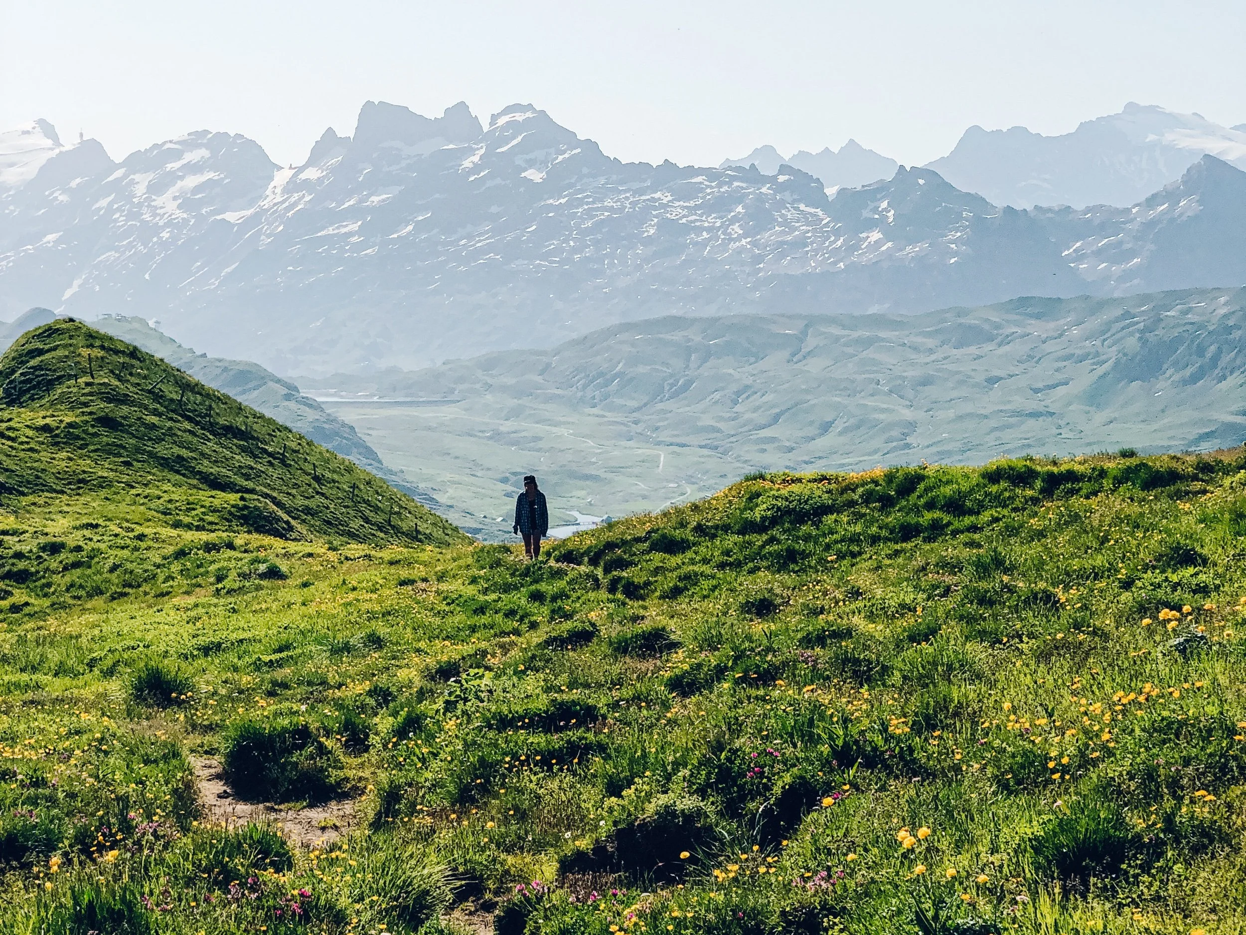
5 Lakes Hike (Gotthard): Andermatt

Out of all the possible “5 Lake Trails” in Switzerland, this one is definitely the most under-the-radar. Which is surprising, because it is right off one of the most famous passes in the country: the top of the Gotthard Pass. This trail is really stunning in its own way, filled with geometric boulders and inky blue lakes (way more than five!) and high-altitude moors and mossy rocks. Once you pass the first lake, the busy roads melt away, and all that is before you in mountains. Mountains in a harsh, yet uniquely beautiful, landscape. Definitely don’t skip the short detour up to Gatscholalücke. And best of all, it’s pretty empty. We went on a sunny Sunday, and there were hardly any people on the trail! What’s not to love about that?
P.S. If you are coming with a car, do yourself a favor and park next to the dam (Lake Lucendro), and save yourself a couple kilometers of road walking.
Start/end: Gotthard Passhöhe
Basic Route: Gotthard Passhöhe - Lake Lucendro - Laghi della Valletta - Gatscholalücke - Laghi d'Orsirora - Lago d'Orsino - Gotthard Passhöhe
Length and Rating: 14km, 650 meters up/down, 4 hours. Moderate.
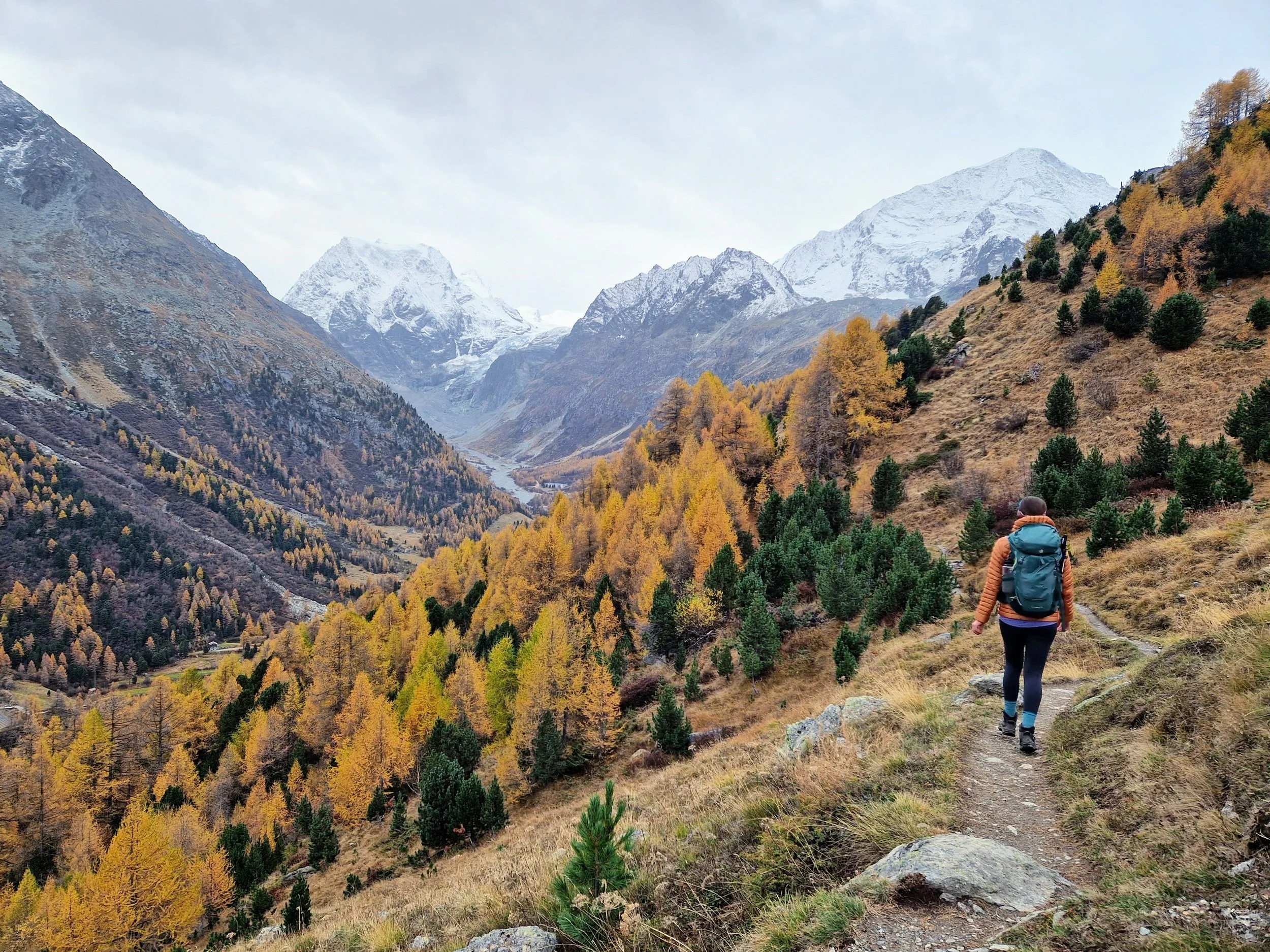
Tremorgio to Dalpe: Ticino

Here it is, the best hike of summer 2021. I loved every second of every step of this trail - even the last few steep kilometers on my jelly legs (OK, maybe I just blocked that very last bit out). But this hike truly has it all: vibrant alpine lakes, spiky mountains, high plateaus, colorful valleys, waterfalls, that perfectly idyllic remoteness. The trail is quite diverse, too. I love climbing the boulders up above Lago di Leit, and the early fall colors in the high alpine meadows (which I’m sure are covered with wildflowers in the summer), especially how they contrasted with the deep cerulean water of Lago di Morghirolo. And normally I would curse a long, 3-hour descent, but the landscape is so stunning, it’s worth the sore legs. It’s a long hike (plan for at least 6 hours of moving time), which is what makes it a difficult trail, but it is truly excellent from start to finish. Run, don’t walk, to hike this one before the season ends.
Pro tip: If Capanna Leit is selling their alpine cheese - buy some! You won’t regret it.
More photos of Tremorgio to Dalpe
Start: Tremorgio (accessed from the Rodi-Fiesso cableway)
End: Dalpe (please check the Post Bus schedule, as it is irregular)
Basic Route: Tremorgio - Alpe Campolungo - Capanna Leit - Lago di Leit - Lei di Cima - Lago di Morghirolo - Capanna Tencia - Sgnoi - Dalpe
Length and Rating: 16km, 900 meters up/1500 m down, 6 hours. Difficult.