Summer Wanderweg: Favorite Hiking Trails of 2020
Just like that, summer hiking season of 2020 has arrived!
I’ve always been incredibly grateful to live in a country with so much natural beauty spilling out from all angles, and with seemingly endless opportunities to explore it…but never more so than this year.
Like last year’s list, I’ll be adding to this one as I go. As Raunaq and I have been getting more comfortable with the terrain and our own personal skills, most of these hikes are around the moderately challenging to challenging level (but all under a T4 rating). You can expect at least a few new hikes per month - maybe more, if I am feeling extra ambitious!
For those new to Swiss hiking, start here. And for more trails, check out my 2019 hiking and 2018 hiking lists.
Three Lakes of Alpstein: Appenzell
Federispitz: Central Switzerland
Edelweissweg: Zermatt
Jöriseen: Graubunden
Five Lakes Trail: Zermatt
Lausanne to Vevey: Vaud
Four Lakes Trail: Engelberg
Pilatus Kulm: Central Switzerland
Surenenpass: Central Switzerland
Sentiero Cristallina: Ticino
Cassongrat and Tectonic Arena Sardona: Graubunden
Lötschental Höhenweg: Valais
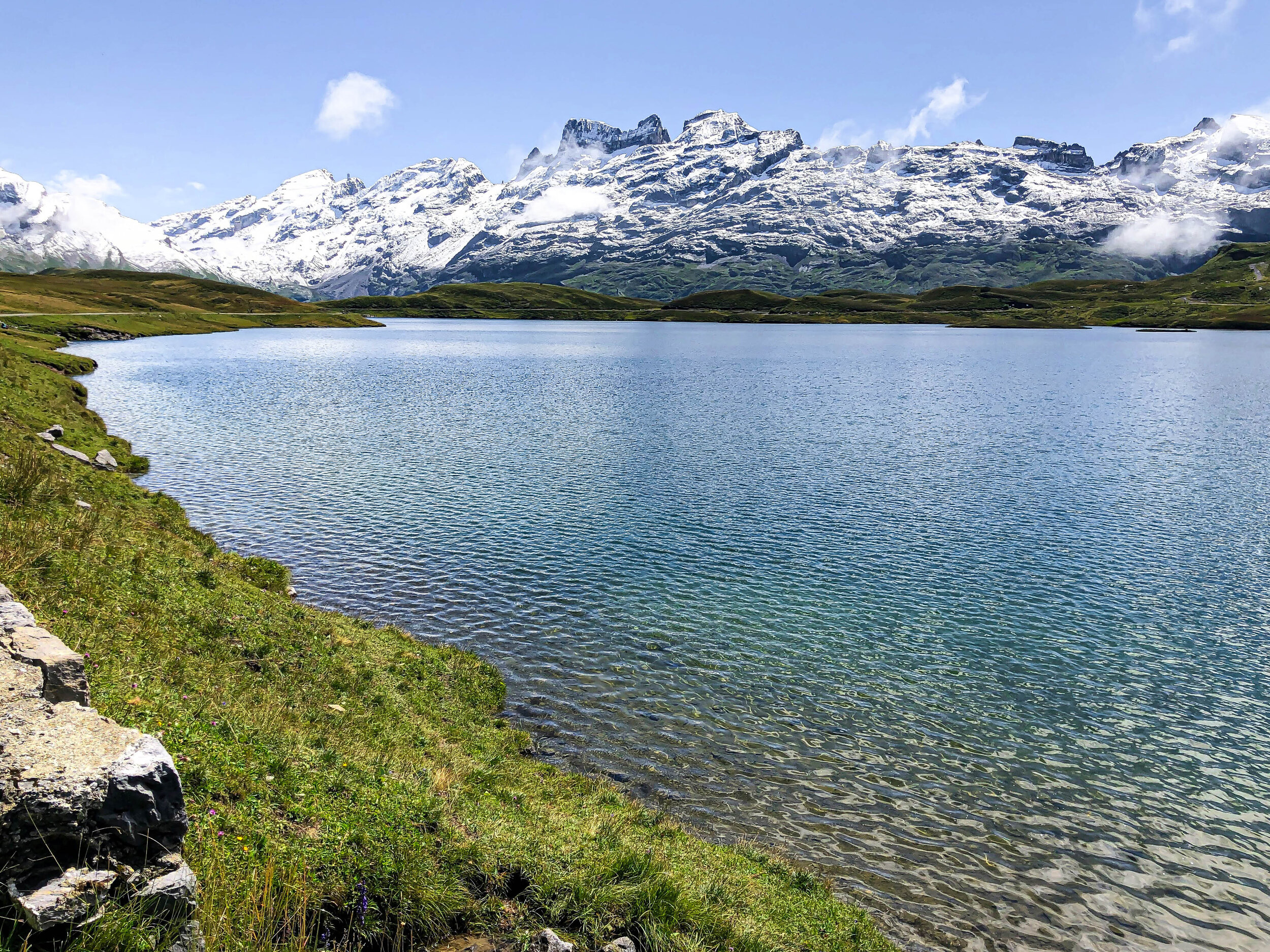
Three Lakes of Alpstein: Appenzell, Northeastern Switzerland
A seriously gorgeous hike that makes you feel like you are in the heart of Switzerland.
The namesake three lakes (Seeaplsee, Fählensee, and Sämtisersee) are all beautiful in their own right, but this trail has so much on offer: a heart-pumping climb for a bird-eyes view of Seealpsee, the most charming herdsmans village of Megaslip tucked high and deep in the mountains, and sweeping views of Santis and the sharp, distinctive ridges of the Apstein - just to name a few of the highlights. There are so many more! Honestly, Appenzell never ceases to amaze. This whole region is a favorite.
But you’ll work for it. Plan for about 6-8 hours of hiking time, with about 1150 meters of collective ascent. There are no exposed areas or ridges, but a few places have a big drop-off where there is a security cable. Currently (we hiked in mid-June), there is one BIG snowfield right after the Widderalpsattel. Luckily, I had my YakTrax “shoe chains” with me to use, so I felt much more comfortable making my way through. The path through the snow is narrow (the width is only one foot right in front of the other), but the angle isn’t too bad and while a bit scary, it was passable. Finally: The last bus from Brülisau leaves at 6:15pm, so plan accordingly. It’s best to give yourself an earlier start, to ensure you aren’t rushed and have time to enjoy all three of the lakes.
More photos from the Three Lakes of the Alpstein hike
Start: Wasserauen Bahnhof
End: Brülisau
Basic Route: Wasserauen – Seealpsee – Unterstrich – Meglisalp – Widderalpsattel – Bollenwees am Fählensee – Sämtisersee – Plattenbödeli – Brülisau
Length and Rating: Challenging. The incline and length will make for a long day. 18km, 1150m ascent, 6-8 hours
Federispitz: Walensee, Central Switzerland
A beautiful BEAST of a hike with sweeping views of the Walensee and Glarus Alps
The climb to the top of Federispitz is not for the faint of heart (1400 meters of elevation gain in 8 kilometers means you are climbing the entire first half of the hike). But with great effort comes great reward: incredible views of the Glarus Alps, Appenzell Alps, Walensee, Zürichsee. There seem to be plenty of different routes for this hike - when we arrived at the summit, there were people arriving from a bunch of different directions. We opted to start from Ziegelbrucke, and then once at the summit, took an alternate path down that led to Weesen. I highly recommend this route. The descent is a knee-buster, but the trail weaves through field after field of wildflowers, the embodiment of every Swiss pastoral dream you’ve ever had. For icing on the cake, pack a bathing suit for a post-hike swim in Walensee.
It’s a tough one. Wear sturdy hiking boots, bring your poles, prepare to sweat, and make sure you have a head for heights: the “Federigrat,” the ridge right before the summit, is quite narrow. Remember that what comes up, must come down - and because there is no gondola or mountain transit at Federispitz, you’ll need to walk the entire way back to lake level. Due to it’s location at the north end of the Alps, the summit is accessible much earlier in the year than at many other locations, making it a great hike for early summer (although an ambitious one, if its your first hike of the season!).
More photos from the Federispitz hike
Start: Ziegelbrücke Bahnhof
End: Weesen
Basic Route: Ziegelbrücke - Grüt - Obernänen - Federigrat - Federispitz - Weesen
Length and Rating: Difficult. This hike is for those who like long, strenuous climbs, although no technical experience is required. 14km, 1400m ascent/descent, 4-5 hours
Edelweissweg (Höhbalmen Höhenweg): Zermatt, Valais
This isn’t just the best hike in Zermatt - this is the best hike we’ve done in Switzerland.
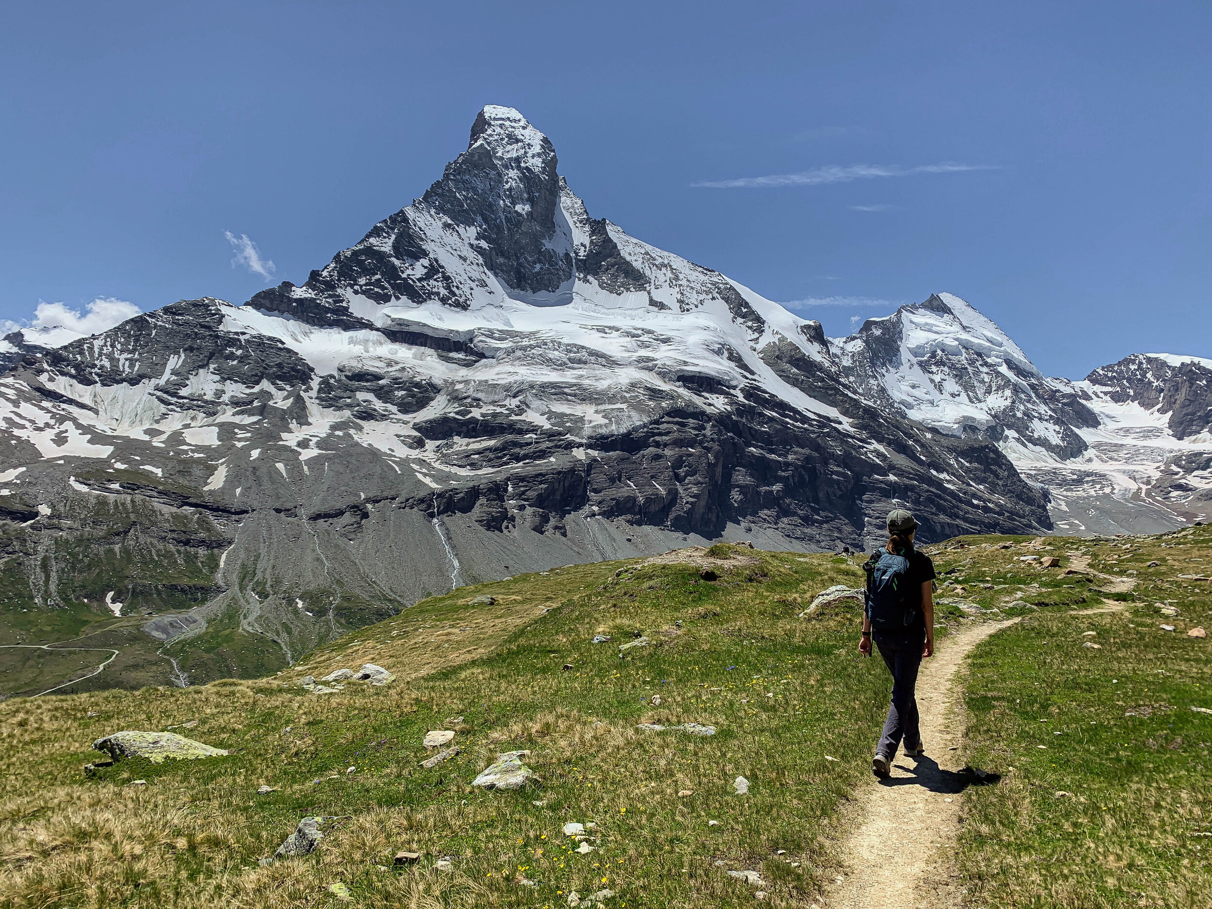
And maybe the best-kept secret, too. I have no idea how this trail isn’t more popular.
Every single stage of this trail is wonderful. The first initial climb from Zermatt to Trift cuts up through the mountains, along the Triftbach river. Numerous rare alpine flowers blossom along this path, including the elusive wild edelweiss. After about 850 meters, we reached the charming pink and blue Hotel du Trift (it’s very Wes Anderson-esque!), sitting in the high alpine valley surrounded by a stunning cirque of high peaks and glaciers. The subsequent climb to the high plateau above Trift was probably one of my top Swiss experiences to date: the extraordinary moment when I reached the Höhbalmen plateau, and the tip of the Matterhorn came into view. It’s unforgettable. The world’s most famous mountain, right there in front of you. The trail continues along the Höhbalmen plateau, then cuts parallel across the mountains high above the Zmutt valley with the Matterhorn drawing closer and closer. The trail is narrow in spots along this part, and felt a bit exposed (simply because we were so high up) but really was quite safe. The final segment of the hike drops down through pretty meadows along the north side of the valley, through streams and glacial waterfalls and the tiny wooden hamlet of Zmutt.
Zermatt is well-known as home to the Matterhorn, and there are plenty of trails that will get you a Matternhorn-view for far less effort. But this trail feels wonderfully wild. There are no mountain trains, no gondolas, no cable cars. With the phenomenal views of all the 4,000-meter peaks in the area, it would be an epic hike without the unparalleled views of Matterhorn. But you get that, too. Easily one of the best hiking days we’ve ever had. Pick a promising day, and hit the trail.
More photos of the Edelweissweg (Höhbalmen Höhenweg)
Start: Zermatt (trail begins in the village, behind the restaurant Grampi’s)
End: Zermatt
Basic Route: Zermatt - Alterhaupt (Edelweiss hut) - Trift - Höhbalmen - Zmutt - Zermatt
Length and Rating: Difficult. 20km, 1250m ascent/1250m descent, 7 hours.
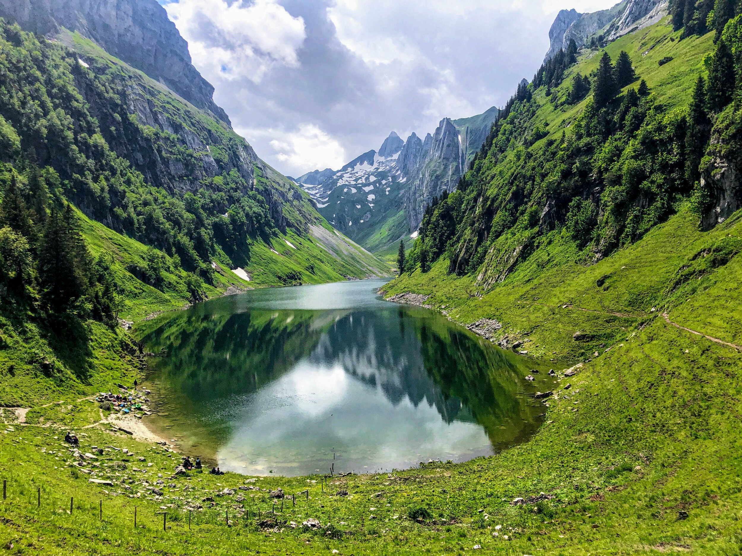
Jöriseen Rundweg: Davos, Graubünden
The glacial Joriseen are one of those “have to see it to believe it” kind of places, in one of the most uniquely stunning spots in Grisons.
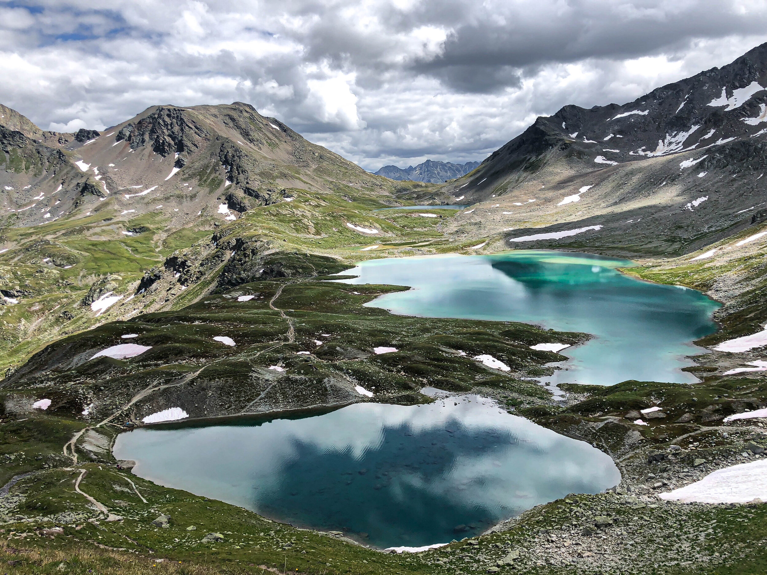
This has been on my Swiss bucket list for some time, and let’s just say that it exceeded all my expectations. I always thought this region was a bit far for a day trip, but even though it’s a long travel day coming fro Zurich (around three hrs each way), it’s hands-down worth the journey.
The landscape in this area of Graubunden is striking and barren - it felt a bit more wild to me than some of the “traditional,” pastoral Swiss landscapes. There is a harsh, other-worldly beauty in its remoteness. It was as though we had been dropped into Middle Earth. The Jori lakes are hidden in the Silvretta Alps, and the stark, craggy mountains and mossy green rocks provide a remarkable contrast to their vibrant aquamarine and deep-blue waters. It was partly cloudy the day we hiked, and truly incredible to watch the colors of the lake shift with the sunlight (click through the photos to see how vivid the green can get when the light hits just right). Completely epic, and unlike anything we have seen. Some of this hike involves climbing up scree, but the most difficult part is the altitude: you’ll consistently be above 2,000 meters (highest point is 2778m asl), so the air might feel thin.
Above all, this trail left me in awe of the great natural diversity in Switzerland. Seriously, how can this tiny country pack in so many uniquely beautiful landscapes? I can guarantee that this will not be our last hike in this area.
More photos of the Jöriseen Rundweg
Start and end: Wägerhus Postbus stop (makes sure to check schedule for the last bus)
Basic Route: Wägerhus - Winterlücke - Jöriseen - Jöriflüelafurgga - Wägerhus
Length and Rating: Moderate. 12km, 4-5 hours.
Five Lakes Trail (5-Seenweg): Zermatt, Valais
One of Zermatt’s most popular trails, and for good reason: it’s low effort with a the super high reward.
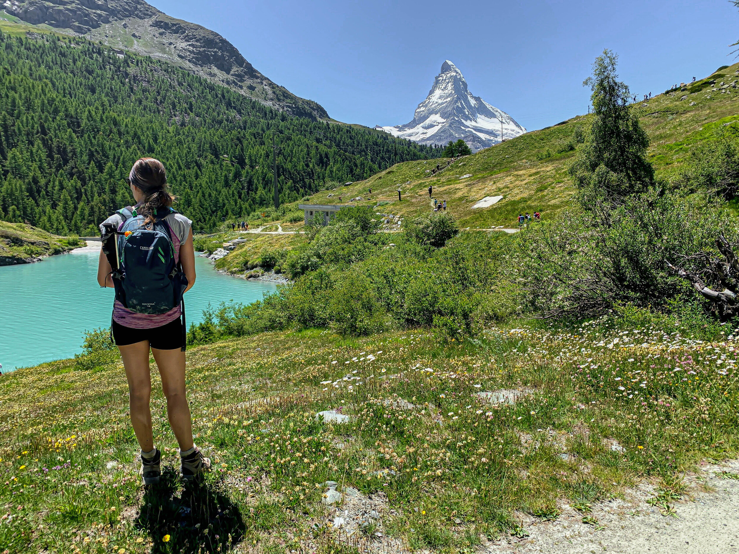
Sweeping views of the Matterhorn (sometimes perfectly reflected in one of the lakes) and the surrounding mountains and valleys makes the 5 Lakes trail a family-friendly classic. The terrain is really varied, and gives you a little taste of everything.
Each lake is a different size, shape, color, and each one offers its own unique attraction. On a calm, clear day, Stellisee will perfectly reflect the Matterhorn. Grindjisee is surrounded by a tranquil grove of Swiss stone pines and lined with rare wildflowers, Grünsee lives up to it’s namestake and is a deep emerald green (and swimmable!). Moosjisee might be more reservoir than lake, but is fed with glacial waters that turn a striking milky turquoise color, and Leisee is loud and fun and packed with families. This trail connects with a whole host of other hikes, so you can easily make this day longer if you want. Definitely make the quick detour up to Fluhalp (just 20 minutes past Stellisee) - if you get lucky, you’ll stumble across a herd of the Valais Blacknose sheep. They are unique to this region, and quite possibly the world’s cutest sheep.
More photos of the 5 Lakes Trail (5-Seenweg Zermatt))
Start: Blauherd station
End: Sunnega station
Basic Route: Blauherd - Stellisee - Grindjisee - Grünsee - Moosjisee - Leisee - Sunnegga
Length and Rating: Moderately easy. 10km, 2-3 hours.
Lausanne to Vevey (Alpine Panorama Trail, Stage 24): Vaud, Western Switzerland
Hiking through the Swiss Riviera, as its called, isn’t your typical alpine summer trail.
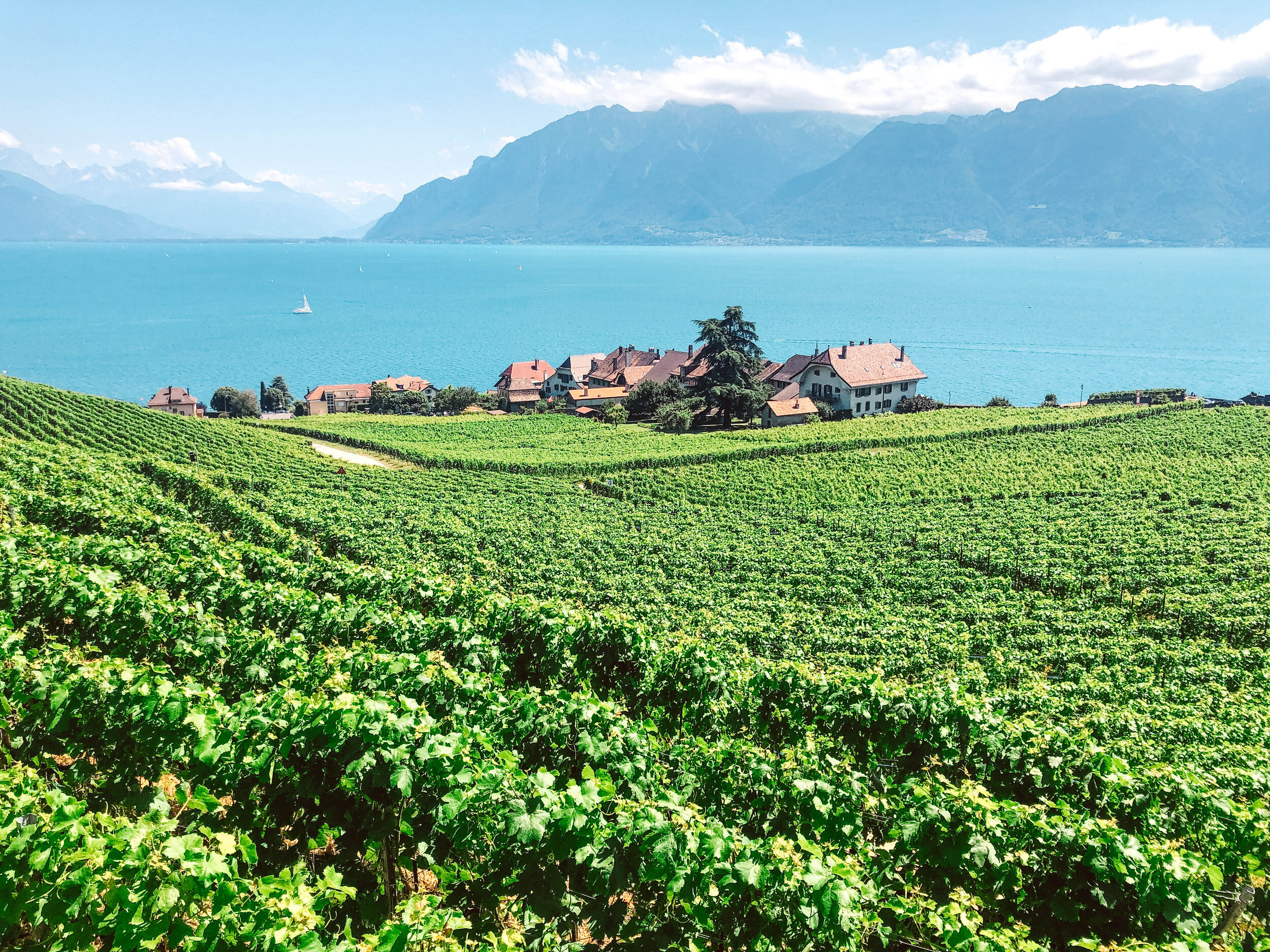
It is more of a long, sun-drenched stroll...through one of the most picturesque regions in Switzerland. There is a certain “je ne sais quoi” in the air here (it is the French region, after all). The whole vibe is leisurely and deliciously sun-drunk. It feels like you are on vacation. Which is why even though this hike can be done year-round…save it for the summer.
We started in Lausanne and ended in Vevey: 5 hours and 20 gorgeous kilometers along the lake and up through the Lavaux vineyards. Along the way, we passed through the old traditional wine villages of St-Saphorin, Rivaz and Epesses, terraced vineyards on one side and the turquoise, ocean-esque Lac Léman below. On the other side of the lake is France, and beyond that, the outlines of both the French and Swiss Alps. All the towns are connected by regional train, so you can make the hike as long or as short as you want. Definitely bring or wear your bathing suit! The sun is strong, and there are so many perfect spots for a swim, especially in the areas around Lausanne, Lutry, Cully and Vevey. The Swiss Riviera, indeed.
More photos of the Lausanne to Vevey hike
Start: Lausanne
End: Vevey
Basic Route: Lausanne - Lutry - Villette - Cully - Epesses - Rivaz - St-Saphorin - Vevey
Length and Rating: Moderately easy, all paved pathways. Only factors to consider are the length (and heat, depending on the day). 20km, 5 hours.
Four Lakes Trail: Engelberg, Central Switzerland
Four deep blue mountain lakes, charming villages and incredible views of the Central Alps.
There’s not too much difficulty with this hike, and with gorgeous views every step of the way, it makes for a truly great day out in the mountains. I opted to start the trail at Melchsee-Frutt and end at Trübsee (with the cable car connection down to Engelberg), but you can go in either direction. The whole hike is really beautiful, but the stretch between Tannensee and Engstlensee was my very favorite: green hills, snow-capped mountains, hundreds of cows (and cowbells), tiny villages with little wooden farms and bright white chapels. It’s seriously SO picturesque. Normally, I choose hikes that are big sweaty challenges…but sometimes, it’s nice to just amble along and enjoy the views. The only semi-tough part of this hike is the climb up to Jochpass. With pretty wide paths and cable car connections, I’d say this one is pretty family-friendly, too.
I also did this hike solo. I think that if you want to hike alone, but are nervous - try it out with this one. There are no technical difficulties, and with plenty of villages and mountain stations along the way, you are never really alone.
More photos of the Four Lakes Trail in Engelberg
Start: Melchsee-Frutt talstation
End: Trübsee talstation
Basic Route: Melchsee Frutt - Tannensee - Engstlensee - Jochpass - (detour to Trübsee
Length and Rating: Moderately easy. The only moderate section is the trails up and down Jochpass. 15km, 4-5 hours.
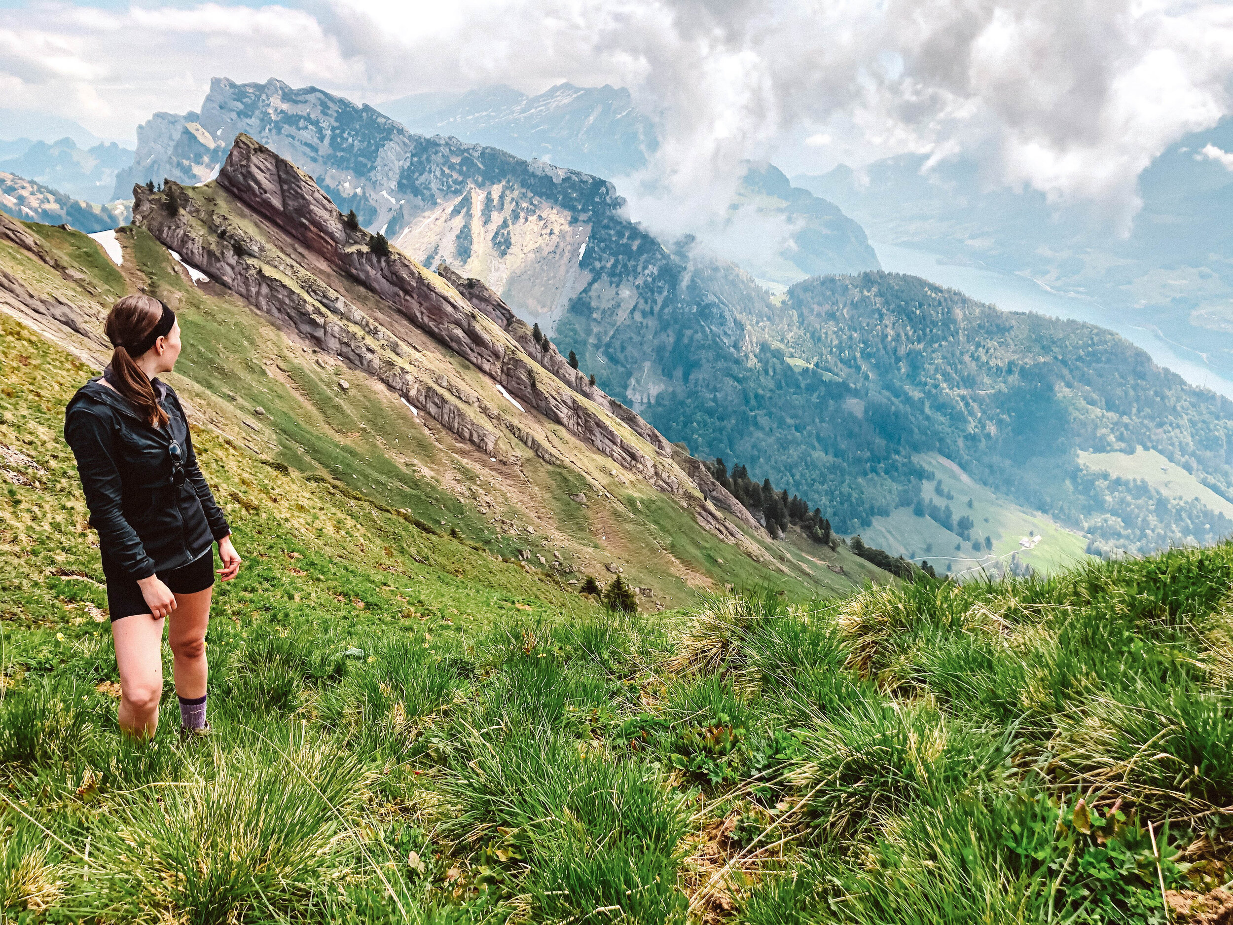
Pilatus Kulm: Central Switzerland
Countless switchbacks that lead all the way to the top of the famous Mount Pilatus.

The Pilatus website describes this trail as “classic and conditionally demanding,” and I’d have to agree on both points. You’ll need to gain 1,600 meters of elevation to get to the top, and the incline is consistent the entire way - it’s a great leg workout. But it’s certainly a classic! Plus, there aren’t any exposed areas or steep drop-offs, so this hike is definitely one of the “easier” mountain climbs you can do in the area. I really enjoyed the slow changing of the landscapes as you hike higher and higher: winding through the forests that open to wide panoramas of Central Switzerland and huge cliffs of the Emmental Alps. Truthfully, the hike wasn’t too bad! I was pleasantly surprised, and even got to the top more quickly than I anticipated. Even though the fog rolled in and pretty much obscured my view (what can you do, right?!), it didn’t diminish that sense of accomplishment! This route follows fairly close to the PilatusBahn, and it is only slightly taunting to see the bright red train peacefully gliding by as you sweat (ha!). And fun fact: the Pilatus railway is the steepest cogwheel train in the world! My legs were very grateful to have a ride back down, too.
More photos of the Mount Pilatus hike
Start: Alpnachstad
End: Pilatus-Kulm
Basic route: Alpnachstad - Ämsigen - Chilchsteine - Pilatus Kulm
Length and Rating: Moderately challenging. The path is clearly marked, and the only difficulty is the constant incline. 9km, 1600 meters ascent, 3-5 hours.
Surenenpass: Central Switzerland
The day hike from Engelberg over the Surenen Pass is considered a classic of Central Switzerland.

The Surenen Pass is a high mountain pass across the Urner Alps in the canton of Uri in Central Switzerland, that connects the villages of Engelberg and Attinghausen. I opted to start at Fürenalp, but since this is a point-to-point trail you can start either way. This direction has a more gradual ascent, and a steeper descent - but, as with most Swiss hikes, there is no wrong decision. The views are extraordinary either way. The first part of the hike, from Fürenalp to Surenenpass, was full of grazing cows, local flora, and small farms selling homemade cheese (this hike is actually part of the “Alpine Cheese Trail”). The second section, from Surenenpass to Brüsti, was marked by steep gravelly trails and dramatic craggy peaks with filtered fog. I opted to take the cable cars both ways, at the start and at the end, which saved me about 1000 meters total. Impressive, beautiful hike!
More photos of the Surenenpass hike
Start: Fürenalp (Fürenalp–Engelberg cablecar)
End: Brüsti (Attinghausen–Brüsti)
Basic route: Fürenalp - Stäuber - Blackenalp - Surenenpass - Brüsti
Length and Rating: Moderate (if you utilize the cable cars at the beginning and end). 16km, 4-5 hours.
Sentiero Cristallina: Ticino
Stony mountain slopes, crystalline rock, high moorland, glacial alpine lakes, remote huts - this trail has it all, and then some.

Honestly - I hadn’t given much thought to the Ticino Alps. To me, Ticino meant palm trees and turquoise rivers and Mediterranean vibes…but not remote alpine hikes. But wow, do I stand corrected. We embarked on stages 2 and 3 of the Sentiero Cristallina (with an overnight at Capanna Cristallina), deep in the Ticino mountains, and I was blown away. Stage 2 leads from the Robiei reservoir up to the Passeo di Cristallina, passing alpine lakes and - if you are lucky - herds of ibex or chamois! The last stage (Stage 3) feels completely different. The route leads from Capanna Cristallina, down the stony mountain slopes into to lovely Alps and forests. I loved being on this trail with the morning sun, the warm rays brightening up the high moorlands of the Val Bedretto.
More photos of Stage 2 and Stage 3 of the Sentiero Cristallina hike.
Start: Robiei (S. Carlo (Val Bavona))
End: Airolo Funivia
Basic route: Robiei - Passeo di Cristallina - Lago Sfundau - Capanna Cristallina (stay overnight) - Alpe di Cristallina - Airolo/Airolo Funiva
Length and Rating: Moderate (if you utilize the cable cars at the beginning and end).
Cassongrat and Tectonic Arena Sardona: Flims
A hike that feels like a journey to the center of the earth.

Not all Swiss hikes are filled with rolling pastoral hills or snow-capped mountains - and that is one of the reasons why I love hiking in this country so much. There is such incredible variety. Case in point: hiking in the Sardona Tectonic Arena in Flims, where the landscape made us feel like we stumbled way, way, way back in time, to a prehistoric era.
The tectonic arena and the upper and lower Segnesboden is the main draw, and rightfully so: it’s a UNESCO World Heritage site and gives an incredible glimpse into the formation of the mountains themselves.
See that horizontal, razor-sharp line running through the mountains in the top photo? That’s the Glarus thrust, the so-called “magic line.” It was created by the collision of two tectonic plates, when huge masses of rocks from different eras were pushed on top of each other. That line separates the 250 million-year-old Verrucano rock from the 35 to 50 million years “young” Flysch rock. But even crazier, the older rock is **on top** of the younger rock (which is why they call these mountains “upside down”). Nowhere else are the results of the processes that led to the formation of mountains as evident as they are here. A natural spectacle, and incredibly fascinating. This entire area is unique and varied, and the whole hike is beautifully epic.
Pro tip: We stopped for lunch at the Fil di Cassons, thinking that it was the highest point of the hike (without consulting our map, oops). Hike up further for 10 more minutes - that will get you to up to La Siala, where you can have lunch with views of the Upper and Lower Segnesboden.
More photos of the Tectonic Arena Sardona hike
Start: Bargis (Flims)
End: Naurus
Basic route: Bargis - Cassonsgrat - La Siala - Segnesboden - Naraus
Length and Rating: 16km, 1000 meters ascent, 4-5 hours. Moderate.
Lötschental Höhenweg: Valais
A hike through Lötschental, the "magic valley," is easily one of the best autumn walks in Switzerlad.

Yes, this is in my summer hikes blog post - but trust me. Save it for mid-to-late-October. Lotschental has one of the densest larch forests in all of Valais, and you are going to want to be there right when they put on their yearly show. A whole forest of larches, all ablaze in their autumn colors of buttery yellow and burnt amber and fiery orange, almost looks too bright to be real. And when the sun hits them just right, I swear, they look electric. It has to be seen to be believed.
The trail itself is well-marked and gorgeous the entire way. Blatten to Fafleralp is known as the “path of reflection,” along meadows and through forests and speckled with little wooden chalets (and herds of Valais black-nosed sheep, if you are lucky!). Schwarzee is one of those tiny, more pond than lake, lakes, that gives a perfect reflection of the fall foliage and snow-capped mountains behind it. And the panoramic views en route to Lauchernalp are jaw-dropping. Especially when the entire valley is aflame in color. The Lötschental is truly a magical valley, rich in exciting legends, centuries-old traditions and local customs (don’t miss Tschäggättä in the winter), and incredible mountain-valley views.
**And next year, I promise I’ll have a dedicated autumn hike round-up!**
Start: Blatten (Dorf)
End: Lauchernalp (Wiler)
Basic route: Blatten (Dorf) - Fafleralp - Schwarzsee - Lauchernalp
Length and Rating: 12km, 800 meters ascent, 3 hours. Easy/moderate.